 Conservation Corner is a weekly article produced by the Forest County Land &Water Conservation Department. For more information contact Steve Kircher, County Conservationist-Land Information/GIS Director at 715-478-1387 or by e-mail at .
This week, I would like to switch to my Land Information hat and talk about your property’s legal description. Understanding the legal description on your land or land you intend to purchase is very important. A legal description is used to describe the location of land in legal documents such as a deed, property tax bills and Managed Forest Law documents.
In this article, I will be referring to the Rectangular Survey System which is also referred to as the Public Land Survey System (PLSS). The PLSS was a legal reference system established by the Federal Government in 1785 to divide and then convey lands from the Public Domain to private land owners.
Here in Wisconsin, PLSS was essentially continuously set in place starting in 1833 and concluding in the north in 1866. The rectangular grid system that makes up the PLSS is a roughly gridded network of surveyed lines and monuments; approximately 6-mile by 6-mile “townships” (36-square-miles) composed of approximate 1-mile by 1-mile “sections”. Some effects of the PLSS are very visible. The grid-like layout of public roadways, roads named using terminology from the PLSS such as “Range Line Road”, farm fields creating rectangular patterns, or even the term “the back forty” are examples of effects resulting from the use of the PLSS.
So, the following example would be described as:
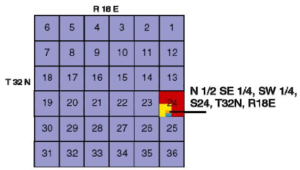
N 1/2 SE 1/4 SW 1/4, S24, T32N, R18E
“The north half of the southeast quarter of the southwest quarter of section 24, township 32 north, range 18 east.”
The easiest way to interpret descriptions is from the right to left, or back to front, or starting with the broadest descriptor and moving to the more specific location.
R18E indicates Range 18 East or all of the townships found with the 18th range line to the east of the principal meridian.
The township number T32N identifies how many blocks/cells the property is to the north or south of a starting point. Township lines run horizontally.
Due to Wisconsin’s baseline (starting point) running along the bottom of the state border there are only townships labeled north.
Where the range (blue) and township (green) lines intersect you have identified the 6-mile by 6-mile township of interest. Each township consists of 36 square miles of area and is broken down into 36 smaller units called “sections”. Each section is a 1-mile by 1-mile parcel of land. Every township section uses the same numbering format. When all the sections of a township are added up, it equals 640 acres of land.
Most parcels of land are smaller than an entire section. Each 1-mile by 1-mile section is divided into 4 quarters each quarter equaling 160 acres. Each of these quarters is labeled with a quadrant direction.
The quarter section of 160 acres can then be divided further into 4 parcels. Each of these parcels (or quarter-quarter sections) equals 40 acres in size.
The parcel of land described is a 20-acre parcel that is the N 1/2 of the SE 1/4 parcel of the SW 1/4 parcel within section 24 (S24). So, halving the quarter of the quarter results in the N 1/2 that we are looking for.
The example legal description N 1/2 SE 1/4, SW 1/4, S24, T32N, R18E describes the land parcel shown below in orange. If the parcel were smaller the same system identifies it even further by continuing to either quarter or half the area of interest.
For more information contact Steve Kircher, County Conservationist-Land Information/GIS Director at 715-478-1387 or by e-mail at .

