
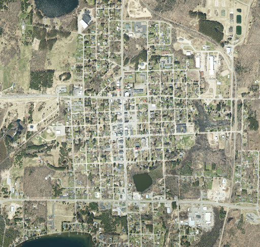
Every 5 years Forest County partners with the Wisconsin Regional Orthoimagery Consortium (WROC) to update the county’s orthoimagery. Orthoimagery is a geometrically corrected aerial photograph. Orthoimagery has been the foundation of regional mapping efforts in Wisconsin since the first consortium was formed in 1995. It started with 1.0-meter resolution film photography of seven counties in southwestern Wisconsin and grew significantly by 2010, when digital orthoimagery was collected across the entire state at 18-inch pixel or better resolution. The sensor technology and processing software has continued to improve the quality and accuracy of the ortho datasets. At the same time, higher pixel resolution imagery is becoming more affordable, and most counties now require 6-inch pixel orthos for their base mapping needs. This year the Wisconsin Department of Military Affairs released a funding opportunity for their NG9-1-1 Grant Program. The NG9-1-1 Grant Program is intended to provide funding to county land information offices for data creation, preparation, and remediation activities necessary for enabling Next Generation 9-1-1. For those that don’t know what NG 9-1-1 is, it is an internet-based system that is replacing the existing 911 infrastructure across the state. NG 9-1-1 improves communication between callers, call centers, and first responders by allowing texts, photos, videos, and data to be transmitted. NG 9-1-1 has already been implemented in Forest County. Forest County, along with the assistance and guidance from WROC applied for a grant in 2024 to upgrade our already scheduled 2025 aerial imagery flight from 6-inch pixel orthos, to 3-inch pixel orthos. The 3-inch orthoimagery that we will receive after the flight in 2025, will be much clearer than our current 6-inch imagery. This will help with improving Forest County’s GIS data, such as road centerlines, building outlines, and hydrobreaklines (surface water edges). This imagery is different from something that you would see on Google Maps for a few different reasons. It is flown during a very small window in the spring when leaves are off the trees, the snow is gone, and the trees haven’t budded yet. Also, the sun angle has to be correct in order to reduce the number of shadows shown on vertical features. Lastly, the accuracy is different compared to Google imagery. WROC imagery is geo-referenced to meet the proper requirements for data creation. Geo-referenced means the image has been tied to a known point on Earth’s surface. The grant award received by the Land Information Department is in the amount of $108,784. The data collected from this flight will be available for this office and the public in 2026!
For more information contact Kayla Littleton, Forest County Land Conservation and Land Information Director at 715-478-1387 or by e-mail at .